
Remote Sensing
Sensors We Use
-
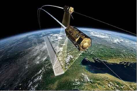
TanDEM-X
TanDEM-X is the first single-‐pass interferometric SAR satellite system. By emitting and receiving synthetic radar waves from two separate satellites flying in formation, we can analyze height information without complications from images collected at different times. The main objective of the TanDEM-X mission is to globally map the Earth’s elevation at a resolution of 12 x 12 meters. This information collected by the German Space Agency (DLR) is not the first globally available digital elevation data, but it does provide more detailed measurements than earlier techniques like the Shuttle Radar Topography Mission in 2000 and the Geoscience Laser Altimeter System that was aboard Ice, Cloud, and Elevation Satellite (ICESat) from 2004-2010.
-

Very High Resolution Satellites
Very High Resolution satellite imagery from some commercial satellites, like the World View satellite series operated by Digital Globe, can provide sub-meter digital imagery. Two images collected within the same pass of the satellite can be combined using computerized stereophotogrammetric techniques and create a digital elevation model. One of the stereo softwares that are openly available to use is the Ames Stereopipeline. This program was originally developed for the Lunar Reconnaissance Mission by the NASA Ames Research Center. By taking advantage of the exceptional flat terrain of mangrove environments, canopy height models can easily be generated using these techniques.
-

Airborne LiDAR
The vertical structure of forests has been successfully studied using airborne laser/lidar scanning and is regarded as the “Gold Standard” for forestry surveys. In addition, lidar is proven technique to validate canopy height measurements acquired from spaceborne measurements like TanDEM-X, Very High Reoslution, and SRTM. The travel time the laser pulse takes from emission to detection by the receiver is directly related to the distance between the sensor and the object. Information about the forest canopy height, forest structure, and ground surface can be deciphered by collection travel time measurements for thousands of laser pulses.
-

G-LiHT Imager
G-LiHT (Goddard’s LiDAR, Hyperspectral, & Thermal Imager) is a portable, airborne imaging system that is able to map the composition, sturcture, and function of terrestrial ecosystems by means of three unique capabilities; LiDAR, imaging spectroscopy, and thermal measurements at a fine-scale resolution of < 1 meter for a wide range of platforms. It is important to note that when imaging different areas it is often difficult to study land area with varied structural and spectral composition. Take for example a forest landscape that has been fragmented by urban sprawl, the thermal reluctance and ability to differentiate canopy heights from other features is augmented by this multi-faceted instrument approach.
-

Terrestrial Laser Scanning
The main advantage of a Terrestrial Laser Scanner (TLS) survey is its ability to capture a 3-D image of the forest structure. Several studies have shown that TLS can measure vegetation parameters such as Diameter-at-Brest-Height (DBH), tree height, leaf area index (LAI), and non-explicit parameters such as wood-to-total-tree area, leaf-to-total-tree area, basal area, stem density, and Aboveground Biomass (ABG) in juvenile trees. Some of the first TLS measurements in mangroves forests were collected in the Everglades.
-

GEDI
GEDI (Global Ecosystem Dynamics Investigation) is a new LiDAR instrument aboard the International Space Station and is a collaboration between NASA and the University of Maryland. Launched in 2018, GEDI has the highest resolution (25 m at each footprint) and densest sampling of any LiDAR in orbit. This instrument collects high resolution observations of the 3D structure of the Earth. Over its 2-year mission, GEDI is expected to gather 10 billion cloud-free observations. The data GEDI gathers will be used to measure vertical structure, with a particular focus on forested ecosystems.
-

ICESat-2
ICESat-2 (Ice, Cloud,and land Elevation Satellite) is a benchmark Earth Observing System mission for measuring ice sheet mass balance, cloud and aerosol heights, as well as land topography and vegetation characteristics. Our team is utilizing space-borne bathymetric mapping to help rise to the challenge of mapping shallow nearshore coastal waters, a slue of ecosystem services and socio-economic benefits. In the field of remote sensing it is supremely difficult to execute efficient mapping due to the poor topographic structure of coastal shores and the lack of available in situ measurements. Luckily, due to our teams tenacity and ingenuity, we have been able to fuse ICESat-2 lidar data with sentinel-2 optical imagery producing the an openly available spatially continuous high-resolution bathymetric maps at multi-regional scales in Florida, Crete, and Bermuda.